Devonport Village
We LOVE living in Devonport. It's like we are on holiday all the time. We love going for early morning bike rides (e-bike). Or walking up Takarunga (Mt Victoria) and/or Maungauika (North Head), our local volcanos. They offer fantastic views towards Auckland city and Rangitoto Island.
It is only a 12-minute ferry ride from downtown Auckland. Devonport is a historic seaside village - where heritage charm and laid-back fun meet sparkling waters and panoramic views from the top of our two volcanoes. Step off the ferry and you’ll find yourself in a postcard-perfect village, with golden beaches, lagoon-like bays, and the majestic rise of Takarunga/Mount Victoria welcoming you ashore. It's like going back in time. Did you know that they filmed part of the Netflix series "East of Eden" in Devonport?
Devonport’s main street, Victoria Road, is lined with beautifully preserved Victorian and Edwardian buildings, hosting boutiques, galleries, and some of the city’s best cafés, shops, chocolatiers. And our online NZ gift shop: Aotearoa.co.nz is based in Devonport.
Stroll past colonial cottages and stately waterfront homes, or wander up to the volcanic cones of Takarunga (Mount Victoria) and Maungauika (North Head) for breathtaking 360-degree views of Auckland’s skyline, the Hauraki Gulf, and the endless parade of sailboats that give Auckland its “City of Sails” nickname.
Explore underground tunnels and WWII relics at Maungauika, North Head, while art lovers will discover a thriving creative scene, with galleries and public art dotted along scenic walking trails. Families and foodies alike will love the playgrounds, seaside picnics, and the village’s lively café culture - don’t miss a treat from Devonport’s famous chocolatiers or a glass of local wine at a historic pub. Whether you’re here for a day or a week, Devonport Village is a place to slow down, soak up the views, and enjoy the magic of Auckland’s prettiest seaside escape.
Discover Devonport
Discover Devonport! We love living in Devonport… We live right at the waterfront, overlooking the Waitematā harbour towards the Ports of Auckland and Auckland city.
Ferry
It takes about 12 minutes to get to downtown Auckland by ferry. The ferry schedule is pretty good… Find out the ferry timetable to Devonport.
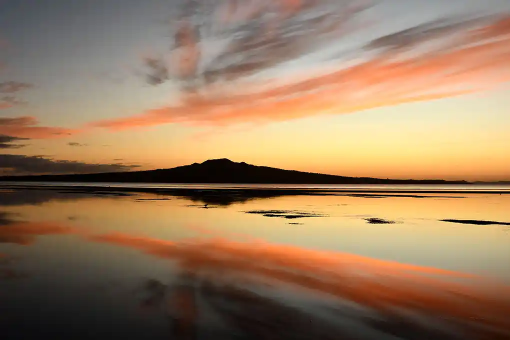
Takarunga
Takarunga / Mount Victoria is the highest volcanic cone on Auckland’s North Shore, rising 66 metres above sea level and dominating the Devonport landscape. Its Māori name, Takarunga, means “the hill standing above,” referencing its prominence over the now-leveled Takararo / Mt Cambria nearby.
Historically, Takarunga was an important Māori pā (fortified village), with terracing and kūmara storage pits still visible on its slopes. European settlers named it Mount Victoria after Queen Victoria, and it later became known as Flagstaff Hill due to the signal station established on its summit in 1841 to aid shipping in the Waitematā Harbour.
The site was further developed for military use in the late 19th century, including the construction of a gun fort, remnants of which remain today. Now a public reserve and one of Auckland’s 14 Tūpuna Maunga (ancestral mountains), Takarunga offers panoramic views of the Waitematā Harbour, Auckland city, Rangitoto Island, and the Hauraki Gulf.
The summit features distinctive mushroom-shaped vents, which are actually part of a water reservoir beneath the hill. The mountain is easily accessible by foot, with well-marked walking paths, and is a popular spot for both locals and visitors seeking natural beauty and a connection to Auckland’s layered cultural history.
Maungauika
Maungauika / North Head is a prominent volcanic cone and ancestral mountain (Tūpuna Maunga) located at the eastern end of Auckland’s Waitematā Harbour in Devonport. Formed over 50,000 years ago, it is one of the oldest cones in the Auckland volcanic field, rising to about 50 metres above sea level.
The name Maungauika means "Mountain of Uika," referencing early Māori occupation dating back around 800 years. Historically, Maungauika was valued by Māori for its fertile soils and strategic coastal position. While the main pā (fortified village) was at nearby Takarunga / Mt Victoria, Maungauika’s lower slopes were used for gardens and settlements. Archaeological finds at its base include some of Auckland’s oldest Māori occupation sites.
From the late 19th century, Maungauika became a key coastal defence site, with tunnels, gun batteries, and forts constructed in response to fears of invasion, notably during the 1880s "Russian scare" and both World Wars. Many of these historic military structures remain and are open to exploration today, including a network of tunnels and rare disappearing guns.
Now managed by the Tūpuna Maunga Authority, Maungauika / North Head is a public historic reserve. It offers panoramic views of the harbour, city, and Hauraki Gulf, and is a popular destination for walking, history, and scenic vistas.
Rangitoto
And then we have the amazing view towards Rangitoto Island… We LOVE Rangitoto. Rangitoto Island is a striking volcanic island located in the Hauraki Gulf near Auckland, New Zealand. It is the youngest and largest of Auckland’s approximately 50 volcanic cones, having emerged from the sea about 600 years ago. If you have time, do visit Rangitoto Island. You can take the ferry from either downtown Auckland or Devonport.
The island is renowned for its symmetrical shield volcano shape, which rises to 260 meters at its summit, and is capped by central scoria cones. Rangitoto is famous for hosting the world’s largest pōhutukawa forest, giving it a vibrant display of red flowers in summer. The island’s rugged lava fields and unique vegetation make it an internationally significant volcanic landform, showcasing all stages of plant succession from bare lava to mature forest.
It is a popular destination for hiking, with scenic trails leading to panoramic views of Auckland and the surrounding gulf, as well as lava caves to explore. And have a look at the lovely little baches (holiday homes).
Culturally, Rangitoto holds significance for Māori, and its name means “Bloody Sky,” referencing a historic battle. Rangitoto's full
name is: Te Rangi i tōtōngia a Tama te Kupea. The island is as protected as a pest-free sanctuary for native wildlife.
Instagram Aotea9
Instagram Aotearoa.co.nz
Aotearoa.co.nz is on online Auckland gift shop since 1997